
Planning
- Details
- Category: Planning
- Details
- Category: Planning
Our Planning System begins
Although the layout of towns can be traced back as far as the Romans with a grid system of roads and buildings alongside, the early beginnings of our present day planning system dates from the industrial and agricultural revolutions in the 1700s.
Before that time most people lived and worked in the countryside but as industry began to grow and agriculture became mechanised, people moved away from the countryside to the towns and cities that had expanded across the country. Cheap housing was built quickly and the towns and cities grew rapidly without little thought for the comforts or levels of sanitation that we are used to now.
As a consequence there was no running water, communal outside toilets which spewed raw sewerage running down the street gutter were the norm. Drinking water was contaminated as it was often taken from the same source that the untreated sewage flowed into, the rivers. The air was thick with smoke from factories and domestic fires that burned coal day and night. Life expectancy was low at 35 with killer diseases such as cholera, typhus and dysentery rife.
Public health reforms began in the 1800s with local authorities gradually taking responsibility for providing clean water and the removal of sewage and refuse. New and rebuilt housing had to have adequate drainage, toilet facilities and an ash pit. Builders had to submit details of these provisions to the local authority before they could start work. With legislation passed in 1875 to tackle overcrowded housing, the Planning System we know today started to evolve.
By the turn of the century legislation continued to improve housing conditions. The Town Planning Act of 1909 prohibited the building of back to back housing and allowed local authorities to prepare town planning schemes. The Housing Act of 1919 gave authority to the Ministry of Health to approve design of houses and the Housing Act of 1930 required all slum housing to be cleared in designated improvement areas.
Between 1919 and 1939 over four million new homes were built leading to a need for planning controls to be extended to cover the countryside. The Town & Country Planning Act 1939 accepted the desirability of countryside rural planning followed by the Restriction of Ribbon Development Act 1935 designed to prevent the sprawl of towns and cities across the countryside.
The Town & Country Planning Act of 1947 formed the basis of the system we have today and introduced two significant changes. Local Authorities had to complete a local plan setting out detailed policies and specific proposals for the development and use of land in a district. Land use would be controlled and planning permission would be required for development. Some sectors, such as agriculture, were granted exemption from planning controls which still exist today.
Further important events affecting planning include -
1955 The national Green Belt system to prevent urban sprawl
1968 County Structure plans introduced to co-ordinate and guide local plans
1988 Regional planning guidance introduced to act as a strategic guide for county structure plans
1990 The Town & Country Planning Act divided planning into forward planning and development control. Forward planning is about setting out the Local Authority's strategy for the future -through a development plan – and development control is about controlling the development that happens
1991 The Planning & Compensation Act 1991 amends the Town & Country Planning Act and introduces the plan-led system, affirming that planning applications should be decided in lin with the development plan
2004 The Planning & Compulsory Purchase Act 2004 scraps county-level structure plans and introduced statutory regional planning called Regional Spatial Strategies.
2008 The Planning Act 2008 introduced a new planning system for nationally significant infrastructure projects (NSIPs). From March 2010 the Infrastructure Planning Commission (IPC) started to make decisions on NSIPs with the intention of improving the efficiency with which decisions are made on such applications
2010 The new Government committed to radically reforming the planning system, based on the principle of localism. Legislation to realise these reforms is currently making its way through Parliament, and includes measures to abolish regional planning, introduce new "neighbourhood plans", and scrap the IPC introduced by the Planning Act 2008
(Source – Campaign to Protect Rural England www.cpre.org.uk)
- Details
- Category: Planning
Major Applications affecting Prestbury
Application No: 10/01243/OUT Location : Land at Starvehall Farm, New Barn Lane, Prestbury
Date registered : 9th October 2010
Proposal : Outline planning application for the development of the site to provide up to 380 houses and apartments including up to 50 extra care, a nursing care facility of up to 80 beds, associated public open space, circulation and a link road. With the inclusion of the link road design all other matters are reserved for future consideration but all such elements to be subject to the design code
Status : Decision pending
14/12/2010 Prestbury Parish Council opposed this application on the following grounds -
PPC OBJECTS to the principle of the proposed development at Starvehall Farm as the proposal -
Is not in accordance with the Cheltenham Borough Local Plan and its adopted policies
Does not comply with the Joint Core Strategy and until its anticipated adoption in 2012, the Gloucestershire Structure Plan and Cheltenham Local Plan saved policies apply
Has not been included in the five year Residential Land Availability document
Fails to recognise the priority use of Brownfield land rather than Greenfield land (which this site is)
Incorporates a parcel of land with long-standing use as a public/schools sports pitch which we believe has only recently been added to the farming land lease. This is contrary to national policy and guidelines as well as the Gloucestershire and Cheltenham Local Development Plans
Includes a Link Road which (I) fails to measure or recognise the strategic traffic management requirements of this area of the borough and Cheltenham Borough as a whole and (ii) fails to address significant safety issues in what would become a heavily populated area
Is premature when judged against the Decentralisation and Localism Bill as proposed by the Coalition Government aimed at (I) empowering local people (ii) freeing local government from central and regional control (iii) giving communities a real share in local growth and (iv) creating a more efficient and more local planning system
In view of these objections in principle, particularly in view of the policy contraventions and prematurity, PPC urged Cheltenham Borough Council to refuse permission for this proposal.
PPC also submitted an integral detailed attachment which can be viewed alongside all the other comments received from both statutory consultees and members of the public on Cheltenham Borough Council's Public Access internet service
Cheltenham Borough Council website www.cheltenham.gov.uk
Application No 10/01243/OUT Location : Land at Starvehall Farm, New Barn Lane, Prestbury
Date : July 2011 Proposal : Revised Plans submitted
Main areas of change :
Link Road
Southern junction of link changed to roundabout instead of T-junction. Tighter bends in southern section to reduce speed. Secondary pedestrian access for some dwellings in the northern section onto Link Road.
Layout
Redesign of southern section of site. Reconfiguration of apartment buildings on northern section. Nursing Home reduced from 80 beds to 60 beds. Creation of additional public space adjacent to apartments.
Allotments
Area of allotments increased, now 17 plots. New pedestrian crossing Prestbury Road to the allotments. Widened footpath adjacent to allotments. Inclusion of parking spaces to the south of the roundabout.
Recreation
Expansion of financial provisions for improving the utilisation of Sports Pitches in Prestbury and addition of new facilities.
Status : Application deferred by CBC Planning Committee November 2011.
Reason :
To allow advice to be provided to the Committee on any implications for the proposed of the Localism Act (enacted 16th November 2011). To allow an opportunity for the applicant to reconsider development proposals in the light of representations and members' concerns during the meeting. To see further clarification on the demand for playing pitches and the status of the land proposed for development. To get further highways advice on the likely cumulative traffic impact of other recent development proposals in the area.
Prestbury Parish Council objections in principle as previously stated remain.
Application No: 10/01243/OUT - Location : Land at Starvehall Farm, New Barn Lane, Prestbury
Date August 2012 - Amended proposals submitted
Application No: 11/00257/OUT - Location : Hunting Butts Farm, Swindon Lane, Cheltenham, Gloucestershire.
Proposal :Outline application for the erection of up to 135 dwellings with all detailed matters reserved (Layout, Appearance, Scale, Access and Landscaping)
Status :
Both Cheltenham Borough Council & Prestbury Parish Council objected to this application and the application was refused. The applicant went to appeal which CBC contested and the application became the subject of a Public Inquiry which started on March 24th 2012. After three days the conclusion of the Hunting Butts hearing was postponed until May due to changes in the National Planning Policy Framework (NPPF) released on March 27th which were expected to change a number of factors relevant to the inquiry.
June 2012 - The Planning Inspectorate rejected Galliard's appeal. Making his decision, Planning Inspector LLoyd Rogers conceded that there was still a need to meet the housing demands but on this occasion the developer had not proved this was the solution. He added "I accept that it is highly likely that development outside the settlement boundary of Cheltenham, probably in the greenbelt, will be necessary if Cheltenham's housing and economic development needs are to be met. However, in this case, I have found that despite the clear benefits of the scheme in meeting some of those housing needs, the particular characteristics of the appeal site mean that the totality of the harm would not be clearly outweighed by other considerations, and the very special circumstances necessary to justify the development do not exist."
Cheltenham Borough Council Public Access
All planning applications, relevant documents, comments and status of applications can be viewed on Cheltenham Borough Council's website www.cheltenham.gov.uk via the Public Access system. Additional information regarding planning matters is also available.
Public Access is an internet service that allows you to submit an application or view details of existing applications for planning permission, building control and other consents
You can -
Make an application for permission
Make an application for building control
Monitor progress of existing applications
Submit comments about applications (note these will be published)
View a weekly list of applications received and validated
View property details of some historic applications
View property details referenced from a map
Search for planning appeals and for enforcement actions that has been taken
To use this service via Cheltenham Borough Council's website www.cheltenham.gov.uk click onto planning and follow the links.
- Details
- Category: Planning
Prestbury Conservation Area
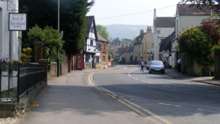
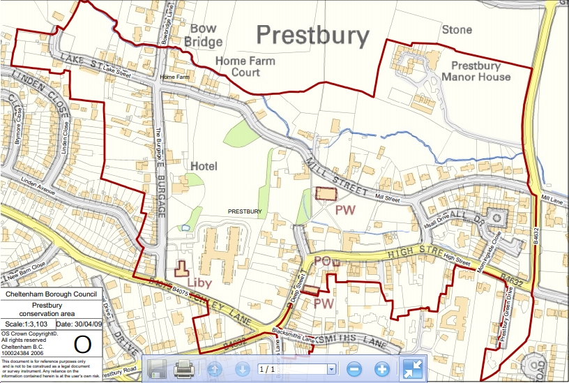
Designated by Gloucestershire County Council on 15th August 1971, its boundary was revised by Cheltenham Borough Council 26th July 2001 and covers 26 hectares. The Conservation Area contains 60 Grade 11 listed buildings/structures, two Grade 11*listed buildings/structures and some locally listed buildings/structures. To the north of the Conservation Area lies the remains of a moated site which is one of six scheduled ancient monuments located within the Borough of Cheltenham.
A supplementary planning document (SPD) was adopted by the Council on 29th June 2009 and outlines the special character that warrants its designation as a conservation area. The SPD is used as a material consideration in determining planning and related applications and replaces previous planning guidance produced in 2003.
Prestbury is an outlying village to the north east of Cheltenham approximately two miles from the town centre and forms part of Prestbury Parish. The Conservation Area covers the original village and has a distinct character. The remainder of the village forms suburban development around Prestbury's historic core.
Prestbury is set at the foot of Cleeve Hill, which forms part of the Cotwold scarp. The Cotswold Area of Outstanding Natural Beauty covers a vast area of land to the east and south-east of Prestbury. Land to the north is designated Green Belt and this land is important to the setting of the Conservation Area.
The Conservation Area is surrounded on its south and west sides by dense, suburban development which is associated with other parts of Prestbury and Cheltenham. Large amounts of development occur along Prestbury Road, New Barn Lane and Priors Road, which form the main roads into Prestbury Village from Cheltenham.
The physical character of the Conservation Area is determined by the form of the roads, enclosed and open spaces and distance views of Cleeve Hill and Agg's Hill. The linear form of the main streets creates long vistas whilst buildings positioned against the back edge of footpath create a sense of enclosed space. Green spaces provide a sense of spaciousness and trees provide natural boundaries. The positioning of Cleeve Hill to the east and Green Belt to the north provides an attractive setting for the village and natural, soft enclosures.
Prestbury Conservation Area has a varied mix of building type, style, age and function. This adds to the special interest of the Conservation Area through the visual architectural mix of buildings, their varied details and materials, and their varied relationship to each other, as well as the assorted uses of buildings and land.
Prestbury has retained its unique village character and qualities through the visual dominance of historically and architecturally important buildings and the retention of their attractive historic settings.
- Details
- Category: Planning
Planning Decisions
All local planning applications have to be decided by the Local Authority which in our area is Cheltenham Borough Council. Prestbury Parish Council is a statutory consultee but does not have the power to decide the outcome of an application.
The Parish Council views all applications that are within Prestbury Parish area and following the same principles as employed by Cheltenham Borough Council in line with current legislation will decide if the Parish Council is in favour of the application or whether it objects to the application. Cheltenham Borough Council will give due weight to the views of the Parish Council when deciding the application.
Both Cheltenham Borough Council and Prestbury Parish Council have to take into account national and local policies as well as material factors that apply e.g.
| Material | Not Material |
| Layout,Density | History of Applicant |
| Privacy | Loss of View |
| Daylight / Sunlight | "No Need" |
| Access / Traffic | Commercial competition |
| Local Economy | Change from previous scheme |
| Noise / Smell | Impact on property value |
| Landscape | Restrictive covenants |
| Previous similar decisions | Ownership of Land |
| Cumulative impact | Right of Acess |
| Rarely, personal circumstances | |
| But each case on its own merits | Source- Trevor Roberts Associates |
If you wish to either support or oppose a Planning Application you should contact Cheltenham Borough Council's Planning Department with the detail of the application, your objections or support in writing or you can register your views on line at cheltenham.gov.uk following the Public Access link.
You can also contact the Parish Council with your views on a relevant application and this will be helpful for the Parish Council's Planning Committee in formulating their response .